

 24Likes
 LinkBack URL
 About LinkBacks
Thought I would share this, maybe you guys already do this?
I use Google maps satellite view along side topo50 when viewing to find deer hot spots. Then on the topo50 app I changed to the aerial imagery base map and discovered its much more detailed from above.
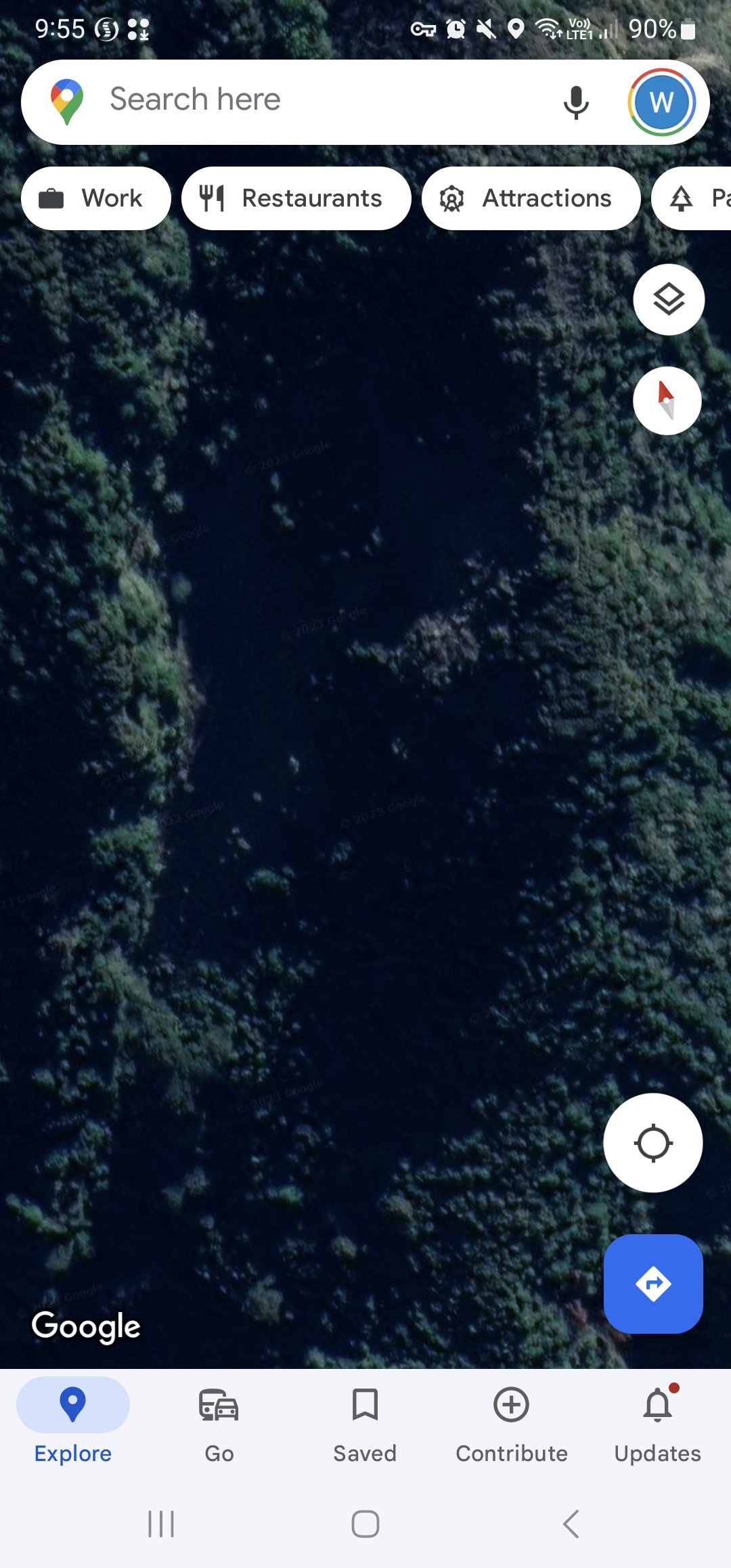
Below is a slip face on spot X from Google earth and its shaded out and can't see anything.
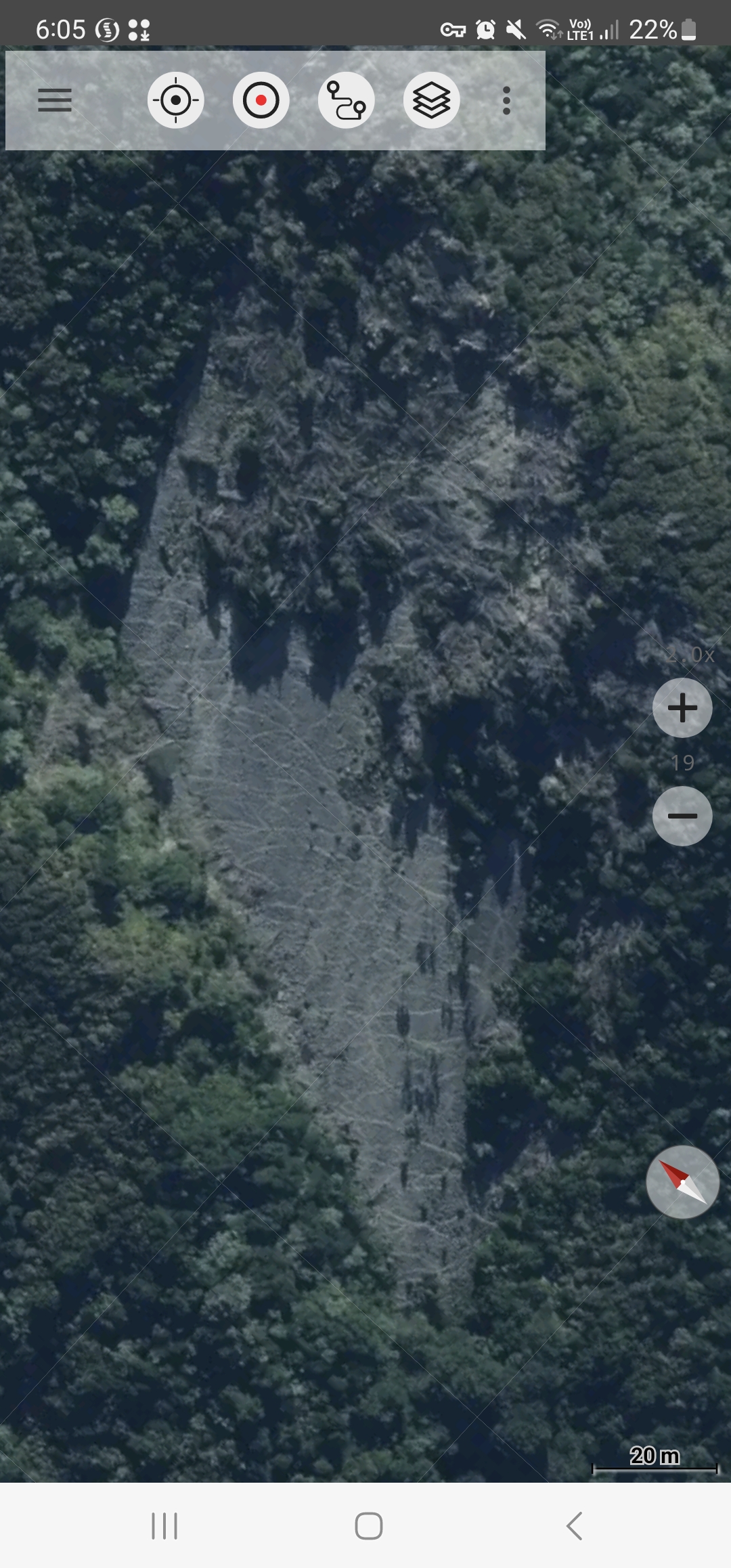
Then using Aerial Imagery on the same area highlights the game trails on that slip face.
Trust this tip is useful for other new hunters.
Welcome guest, is this your first visit? Create Account now to join.
Welcome to the NZ Hunting and Shooting Forums.
Search Forums


User Tag List
+ Reply to Thread
Results 1 to 15 of 17
Thread: Maps for finding spot X
Hybrid View
-
26-02-2023, 10:02 AM #1Member


- Join Date
- Mar 2022
- Location
- Ashburton
- Posts
- 799
Maps for finding spot X
-
26-02-2023, 10:06 AM #2Member
- Join Date
- Mar 2022
- Location
- Ashburton
- Posts
- 799
Next step is to put your foot work in which I discovered yesterday that this area was basically unaccessable

-
26-02-2023, 07:45 PM #3Member

- Join Date
- Apr 2015
- Location
- Geraldine
- Posts
- 25,523
sounds like a challenge..best you share its location with me so I can accept said challenge LOL. Originally Posted by Billbob
 75/15/10 black powder matters
-
26-02-2023, 07:54 PM #4Member
- Join Date
- Mar 2022
- Location
- Ashburton
- Posts
- 799
@Micky Duck Well you might just have to come along with me Originally Posted by Micky Duck
 Micky Duck likes this.
-
26-02-2023, 10:49 AM #5Gone but not forgotten
- Join Date
- Apr 2017
- Location
- Hamilton
- Posts
- 4,129
I have one of the topo apps on my tablet, it has four or five different lots of aerial imagery, and what you can see on different ones is hugely different.
Sometimes it's due to quality of the image, other times it's the angle of the sun when the image was taken.Billbob likes this.
-
26-02-2023, 10:58 AM #6Member
- Join Date
- Oct 2021
- Location
- Wellington
- Posts
- 555
Yup, LINZ Aerial phot is much more detailed. And LINZ Topo 50 also higher res when zooming in on NZTopoMaps App.
Also, after suggesting some improvements to the NZTopoMaps support email, they replied saying they already exist. My phone is android, so can't speak for you weird Apple iOS people, sorry.
Q1. Is it possible to fade the DOC Hunting Permit Overlay blue hatch as you can't really see topo or aerial phot underneath?
A1. When the over lay is on, swipe from the right hand side of the screen, and at the bottom, there is a slider where you can adjust the overlay opacity.
Q2. Is it possible to overlay Topo and Aerial maps and adjust opacity so you can see both?
A2. Go to the main menu > manage layers > (three dot menu top right) > compare maps > two tabs at the top, Map 1 will be whichever layer you have open, e.g. LINZ Topo50. Tab 2/Map 2 select LINZ Aerial Imagery Basemap. This will then open both maps on your screen with an opacity slider, and you can adjust until you can see the aerial with the contours underneath (it doesn't have much other functionality besides that, but still bloody handy!)
Life-changing.
But yes Billbob, then always some hard ground-truthing lessons to follow! I have done exactly the same!
(Tried to upload screenshots of the above steps, but alas, no success. You're all pretty smart, you'll figure it out...)bunji likes this.
-
26-02-2023, 11:00 AM #7Ex stick thrower

- Join Date
- Dec 2011
- Location
- Richmond. Tasman.and Oz
- Posts
- 3,508
Pays to check date flown for aerial image. Ask me how I know this.
Micky Duck and charliehorse like this.Real guns start with the number 3 or bigger and make two holes, one in and one out
-
26-02-2023, 11:01 AM #8Member
- Join Date
- Mar 2022
- Location
- Ashburton
- Posts
- 799
Go on tell us Originally Posted by madjon_
Steve123 and yeah_na_missed like this.
-
26-02-2023, 11:00 AM #9Member
- Join Date
- Mar 2022
- Location
- Ashburton
- Posts
- 799
Oooo thanks for those tips, I get sick of the hunting overlay so dark! Will sort that now. I wish we could self edit topo50 maps for where there are bluffs etc... which is what I came across yesterday.
yeah_na_missed likes this.
-
26-02-2023, 04:04 PM #10Member

- Join Date
- Jan 2020
- Location
- Nelson/Tasman
- Posts
- 4,421
I looked for those settings on NZtopo50 and can't find the compare maps and the overlay I have to go into settings to adjust. This is on Android too
-
26-02-2023, 04:11 PM #11Caretaker

- Join Date
- May 2012
- Location
- Rolleston, Canterbury
- Posts
- 5,197
@Happy Jack they are talking about a different app the NZTopomaps app.
yeah_na_missed likes this.
-
26-02-2023, 04:15 PM #12Member
- Join Date
- Oct 2021
- Location
- Wellington
- Posts
- 555
Hi Happy Jack. Is that the NZTopoMaps app (by Atlogis) or NZTopo50 offline app where you pay for Nth and Sth Islands separately?
Prob should have said this is on the paid/pro version of NZTopoMaps.
I tried the NZ Topo50 Offline maps, but found the detail wasn't high enough. The guy said that's elated to the size of the map/aerial phot file. I asked if you could just load small areas of higher detail, and he said he's looking into it, so I ended up going pro on NZTopoMaps.bunji likes this.
-
26-02-2023, 04:19 PM #13Member
- Join Date
- Jan 2020
- Location
- Nelson/Tasman
- Posts
- 4,421
Ah yep i'm on topo50
yeah_na_missed and Billbob like this.
-
26-02-2023, 05:26 PM #14Member

- Join Date
- Jan 2015
- Location
- Rotorua
- Posts
- 3,944
How do you save the maps for offline use? I kept getting a blue and white checkerboard in Kaingaroa. It works good if you've got coverage and will still give me my position with no coverage just no map Originally Posted by yeah_na_missed
-
26-02-2023, 08:04 PM #15Member
- Join Date
- Jul 2013
- Location
- Waikato
- Posts
- 2,603
Just adjusted the blue overlay much better now ,cheers for the tip!


 Reply With Quote
Similar Threads
-
Finding lost dog.
By Ranal in forum Hunting DogsReplies: 13Last Post: 11-01-2023, 06:02 PM -
Spot satellite messenger, aka findme SPOT
By ROKTOY in forum Gear and EquipmentReplies: 10Last Post: 19-09-2017, 10:44 AM -
finding groper etc?
By silentscope in forum FishingReplies: 11Last Post: 01-11-2014, 09:36 PM
Tags for this Thread
 Posting Permissions
- You may not post new threads
- You may not post replies
- You may not post attachments
- You may not edit your posts
Welcome to NZ Hunting and Shooting Forums! We see you're new here, or arn't logged in. Create an account, and Login for full access including our FREE BUY and SELL section Register NOW!!
All times are GMT +13. The time now is 11:10 AM.

Bookmarks