


 LinkBack URL
 About LinkBacks
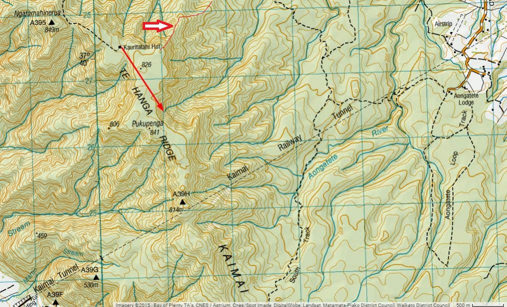
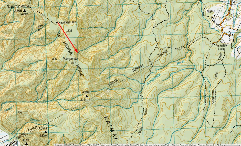
I took a walk up to the Kauritatahi Hut a month ago and had a bit of an adventure trying to get down off the ridge without backtracking. (Which I had to do in the end. That was a long day).
Went as far as the stream I've marked on the map but came to a large drop which turned me back. I came across a track that got me back to the hut but I was wondering if anyone knew how far south this track goes and where it goes to? I was hoping to be able to continue south to the North South track.
Welcome guest, is this your first visit? Create Account now to join.
Welcome to the NZ Hunting and Shooting Forums.
Search Forums


User Tag List
+ Reply to Thread
Results 1 to 15 of 15
 10Likes
Thread: Te Hanga ridge, Kaimai ranges.
Hybrid View
-
16-06-2015, 06:14 PM #1Ejected

- Join Date
- Sep 2014
- Location
- Tauranga
- Posts
- 202
Te Hanga ridge, Kaimai ranges.
-
16-06-2015, 07:37 PM #2Member

- Join Date
- Sep 2014
- Location
- Clarks Beach, (South of) Auckland
- Posts
- 1,739
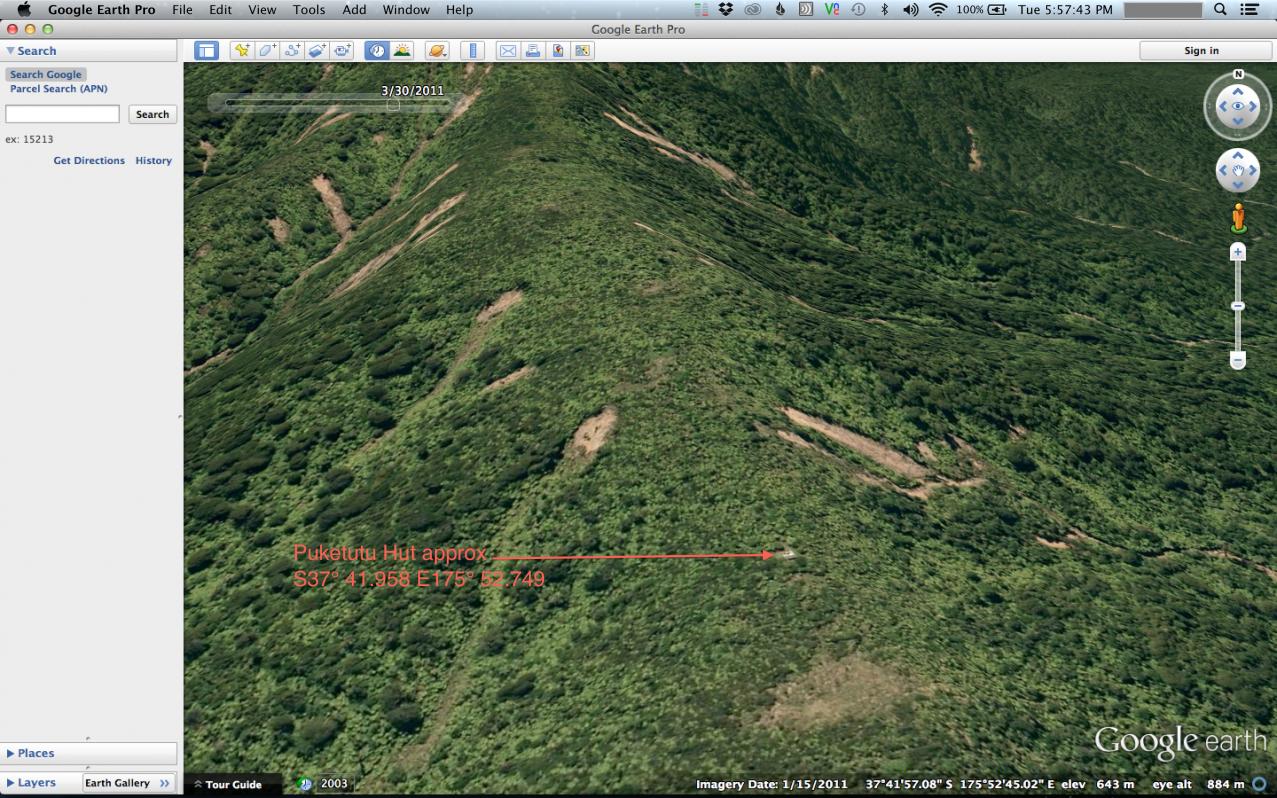
No first-hand knowledge of Ol' Flat-top, but I did a map recce a few years back and thought I spotted where the now unlisted track carries on south, from Kauritatahi Hut to the now unlisted Puketutu Hut.
Jump on Google Earth and if you use the "Historic Imagery" tool, you can access different aerial photos from the past and occasionally see now forgotten tracks. Take a look at the March 2011 imagery for that area in particular.
A few other useful links:
Tramper.nz
Mapspast.org.nz | Current and historical topographic maps (topomaps) of New Zealand
-
16-06-2015, 10:04 PM #3Ejected
- Join Date
- Sep 2014
- Location
- Tauranga
- Posts
- 202
That's opened up quite a big area for me now as well as teaching me heaps about google earth. Thanks heaps strech, greatly appreciated.
Gee that image makes it look easy. I was in knee deep mud & crying for mum.
-
17-06-2015, 12:38 AM #4Member
- Join Date
- Sep 2014
- Location
- Clarks Beach, (South of) Auckland
- Posts
- 1,739
The old man said something similar. It's basically a big swamp. It had him crying for Grandma back in the day too.
-
18-06-2015, 04:00 PM #5Member
- Join Date
- Mar 2012
- Location
- Waikato
- Posts
- 2,189
Same here . Epic spot . Originally Posted by stretch

And no I'm not your dad.
-
17-06-2015, 08:20 AM #6Member
- Join Date
- Sep 2014
- Location
- Clarks Beach, (South of) Auckland
- Posts
- 1,739
Detailed instructions for getting to Puketutu Hut from Upland Rd. http://tramper.nz/3408/puketutu-hut-...ute-info-2009/
Sent from my SM-T800 using Tapatalk
-
17-06-2015, 10:54 AM #7Ejected
- Join Date
- Sep 2014
- Location
- Tauranga
- Posts
- 202
You'll be so proud of me stretch. I've found that article, plotted the track on google earth, transferred that track to basecamp and I am currently downloading the birdseye imagery.
It's been a steep learning curve, tougher than the damn walk!
Thanks again for the inspiration.stretch likes this.
-
17-06-2015, 11:09 AM #8Member
- Join Date
- Sep 2014
- Location
- Clarks Beach, (South of) Auckland
- Posts
- 1,739
Nice one. You can also download gpx files straight from tamper.nz http://tramper.nz/4277/
Did you BUY a Birdseye subscription??? I installed some custom firmware on my garmin that allows me to run Birdseye .jnx files without paying for the priveledge. Geek.
Sent from my SM-T800 using Tapatalk
-
17-06-2015, 11:45 AM #9Codswallop

- Join Date
- Feb 2013
- Location
- The Hill
- Posts
- 23,584
Do tell Originally Posted by stretch
 veitnamcam likes this.
-
17-06-2015, 12:11 PM #10Ejected
- Join Date
- Sep 2014
- Location
- Tauranga
- Posts
- 202
I got a years subscription free with my GPS.
-
17-06-2015, 01:17 PM #11Member
- Join Date
- Sep 2014
- Location
- Clarks Beach, (South of) Auckland
- Posts
- 1,739
Sweet. I'll post some instructions and links later.
Gibo likes this.
-
17-06-2015, 02:39 PM #12Member

- Join Date
- Dec 2011
- Location
- Tauranga
- Posts
- 1,149
I have accessed via this route good pull idea is to do it on a dry day though
-
17-06-2015, 02:42 PM #13Member
- Join Date
- Sep 2014
- Location
- Clarks Beach, (South of) Auckland
- Posts
- 1,739
Basically, you will need to check if this will work on your garmin, download a new firmware file (usually called gupdate.GCD), patch it with a 3rd-party tool, install the newly created patched version of the firmware onto your gps, then either make or find some .jnx files.
Background info worth reading to check compatibility with your GPS, and how to make Birdseye compatible .jnx maps from other sources: http://whiter.brinkster.net/en/JNX.shtml
Where to find the latest official firmware for your garmin, assuming you have an Oregon 6xx (there are similar "wikispaces" sites for other garmin models): http://garminoregon6xx.wikispaces.com/Firmware
The piece of software you will need to patch your firmware: http://whiter.brinkster.net/FirmwarePatcher.html
Sent from my SM-T800 using TapatalkLast edited by stretch; 17-06-2015 at 02:59 PM.
-
17-06-2015, 09:16 PM #14Ejected
- Join Date
- Sep 2014
- Location
- Tauranga
- Posts
- 202
Is that actually a short cut? It seemed very steep through there... Originally Posted by Bonecrusher
You win stretch, you've lost me. Originally Posted by stretch
I'm way back at 'how do I set up the position format on the 64s to read in NZTM2000'.stretch likes this.
-
18-06-2015, 09:35 AM #15Member
- Join Date
- Dec 2011
- Location
- Tauranga
- Posts
- 1,149
[QUOTE=Ricochet;373946]Is that actually a short cut? It seemed very steep through there...
That's why you do it on a dry day so you aren't doing the old two steps forward one back :-)
It just opens a lot more country coming in through there


 Reply With Quote
Similar Threads
-
Hunting in the Kaimai ranges
By Muel in forum HuntingReplies: 88Last Post: 31-05-2014, 04:47 PM -
Clear ridge scopes
By Toby in forum Firearms, Optics and AccessoriesReplies: 13Last Post: 28-05-2014, 10:45 PM -
Wairere Falls Kaimai Ranges
By Toha in forum HuntingReplies: 9Last Post: 14-01-2014, 07:45 PM -
hunting in the Hapuakohe and kaimai ranges?
By marlin_shoota in forum HuntingReplies: 21Last Post: 31-01-2013, 06:16 PM
Tags for this Thread
 Posting Permissions
- You may not post new threads
- You may not post replies
- You may not post attachments
- You may not edit your posts
Welcome to NZ Hunting and Shooting Forums! We see you're new here, or arn't logged in. Create an account, and Login for full access including our FREE BUY and SELL section Register NOW!!
All times are GMT +13. The time now is 11:26 AM.

Bookmarks