

 4Likes
 LinkBack URL
 About LinkBacks
NZTopo does the same Pengy
Welcome guest, is this your first visit? Create Account now to join.
Welcome to the NZ Hunting and Shooting Forums.
Search Forums


User Tag List
+ Reply to Thread
Results 16 to 30 of 36
Thread: Google Earth
-
18-03-2014, 08:24 AM #16Member


- Join Date
- Apr 2013
- Location
- Tauranga
- Posts
- 886
-
-
18-03-2014, 08:33 AM #17Member

- Join Date
- Sep 2012
- Location
- Up in da hills somewhere near Nelson
- Posts
- 9,699
It does to a degree Rusky, but NZtopo doesnt have the same zoom capabilities , and the ariel pics are dont look anything like as clear to my old eyes.
Can you do the DOC boundary overlay on Topo ? I cant see it
I cant find a way to mark tracks on NZ topo either, or save a screenshot, and even marking a spot seems longwinded. Nah, I will stick with WAMSLast edited by Pengy; 18-03-2014 at 08:42 AM.
Forgotmaboltagain+1
-
18-03-2014, 10:22 AM #18Member
- Join Date
- Apr 2013
- Location
- Tauranga
- Posts
- 886
Ok you win Pengy. Ill have to try use WAMS. DoC boundary line is something id love to know ho to do.
-
18-03-2014, 11:38 AM #19Member

- Join Date
- Nov 2012
- Location
- Souith Canterbury
- Posts
- 1,737
Goggle Earth uses WGS-84 or UTM (Universal Tranverse Mercator). NZTM (or the latest Topo map) is quite different, but can be converted (very painfull for hunting etc). I'm not a GIS expert, but do test and provide GPS/GNSS support fro Surveyors and contractors all over the world.
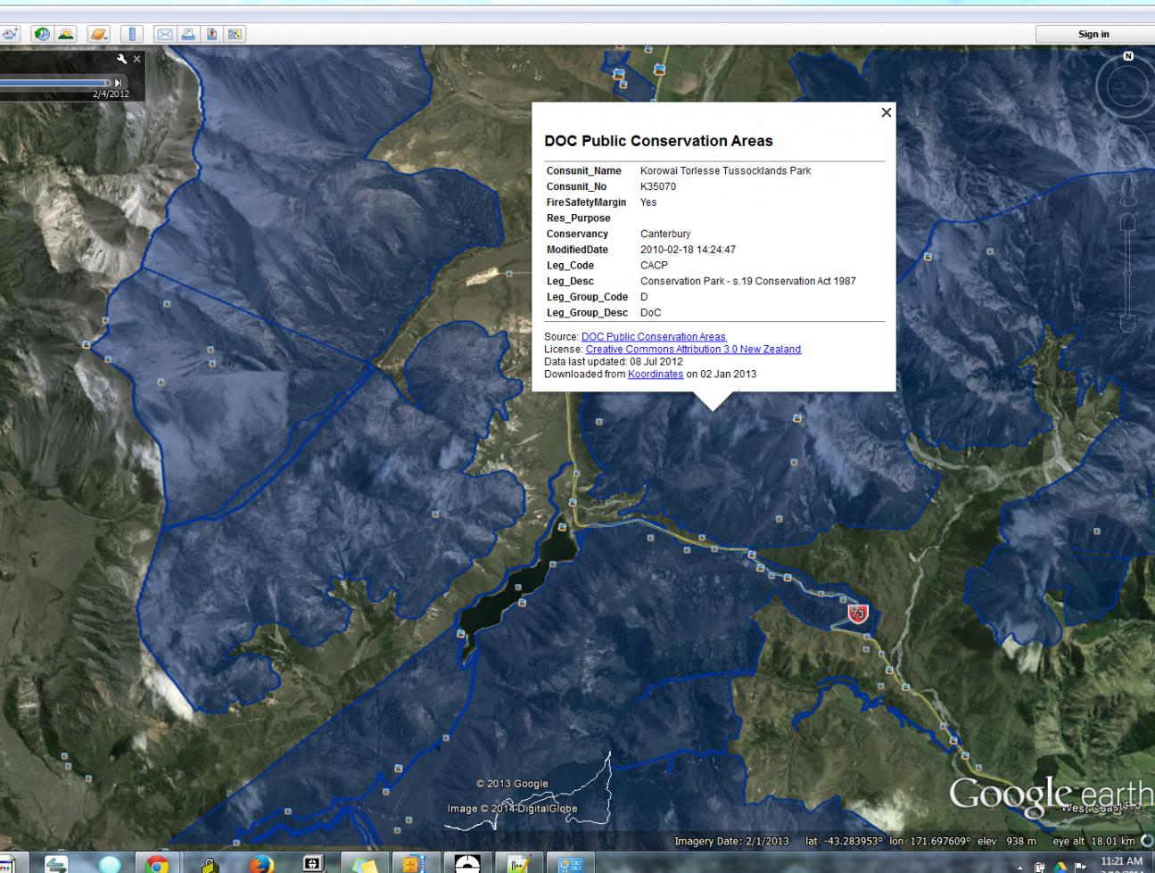
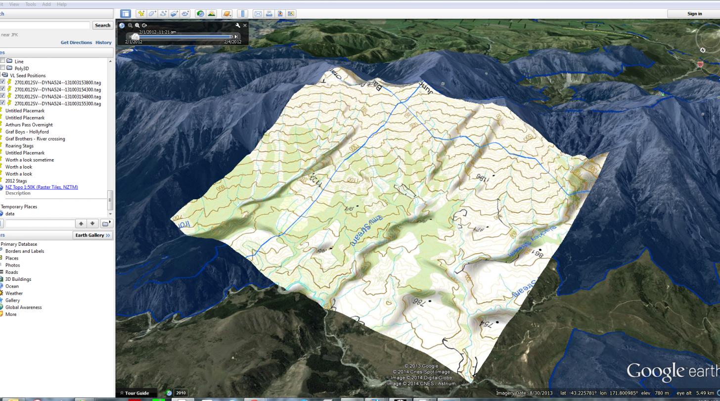
There is many ways to get what you what; set your GPS to WGS-84 and then Goggle Earth positions will work easy. Or, import the Topo maps and Doc boundaries to Goggle Earth. Looks like this:
Are with the Topo layer too:
This data comes from the Koordinates.com site and then exporting the layers as .KML/.KMZ file. These can also be loaded in Apps like Backcountry Navigator (what I use) and the newer Garmin and a few others.
-
18-03-2014, 11:43 AM #20Member
- Join Date
- Nov 2012
- Location
- Souith Canterbury
- Posts
- 1,737
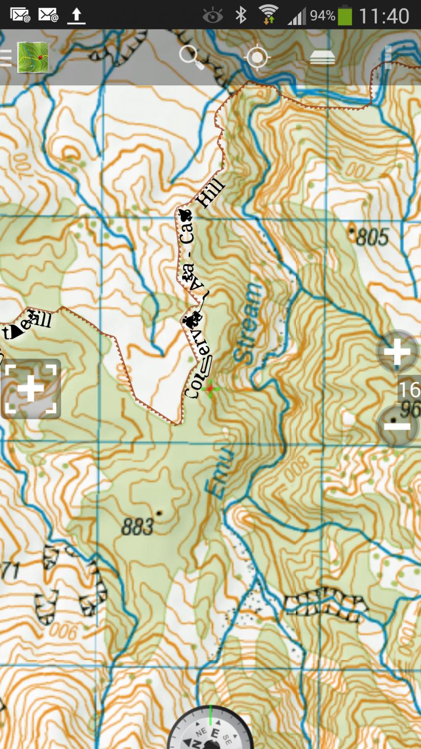
This is the same area with DOC boundaries in Backcountry Navigator (on Android devices only)
-
18-03-2014, 12:02 PM #21Member
- Join Date
- Nov 2012
- Location
- Souith Canterbury
- Posts
- 1,737
Correct, the NZGD1949 was not WGS84, but Google Earth using WGS84. The new system is NZTM200, similar(not the same though) to the UTM system that can be used all over the world. Positions can be converted on the Linz site here Convert coordinates between NZ coordinate systems Originally Posted by Tussock

Converting NZTM to UTM for Emu Stream in the picture above, not the same coordinates:
NZTM ------------------- UTM zone 58 (south)
Northing Easting --- Northing Easting
5214802.0 1505884.0 -- 5192678.2 1055768.9
WAMS is really good for view that areas, I do use it a lot. However, it does rely on an internet connection. Having the exported .KML files on the GPS is real handy.
-
18-03-2014, 12:52 PM #22Member
- Join Date
- Nov 2012
- Location
- Souith Canterbury
- Posts
- 1,737
Should be a scale factory too. Originally Posted by Tussock
-
18-03-2014, 02:59 PM #23Member
- Join Date
- Sep 2012
- Location
- Up in da hills somewhere near Nelson
- Posts
- 9,699
Stuff all that flapping around. I am just going to buy Maptoaster which has ariels as well as DOC boundaries etc.
 Forgotmaboltagain+1
-
18-03-2014, 03:15 PM #24Member

- Join Date
- Apr 2013
- Location
- Wellington
- Posts
- 74
WTF Originally Posted by Pengy

-
18-03-2014, 05:02 PM #25Member
- Join Date
- Sep 2012
- Location
- Up in da hills somewhere near Nelson
- Posts
- 9,699
But only when I can afford it. Freshmap is 2008 version, so a bit out of date now. I will keep the computer based version as I like it for planning trips. Originally Posted by Kaweka_Neil
Forgotmaboltagain+1
-
18-03-2014, 06:17 PM #26Member

- Join Date
- Nov 2012
- Location
- Papamoa
- Posts
- 270
This shit is technical man. Im still Goggling the first post so I can work out what it all means
 Pengy likes this.
-
18-03-2014, 07:31 PM #27Member

- Join Date
- Aug 2012
- Location
- Papamoa
- Posts
- 492
Looked at WAMS and that is just what I was after. Found the coordinates of that clearing I spotted at......... Cheers guys. Originally Posted by Pengy
GravelBen likes this.Everyone is entitled to their own stupid opinion
-
18-03-2014, 08:57 PM #28Member

- Join Date
- Apr 2013
- Location
- Waikato NZ
- Posts
- 223
I wish I had the know how to load this to my gps http://maps.doc.govt.nz/Viewer/Index.html?viewer=rwa
satellite/topo huts tracks and doc plus doc hunting.
-
19-03-2014, 08:24 AM #29Member
- Join Date
- Nov 2012
- Location
- Souith Canterbury
- Posts
- 1,737
Nothing is impossible. With time and money, you can just about do anything! Originally Posted by oneipete
What make and model is your GPS?
-
19-03-2014, 09:35 AM #30Member
- Join Date
- Sep 2012
- Location
- Up in da hills somewhere near Nelson
- Posts
- 9,699
I was a bit disapointed with that DOC mapping website. It runs slow, and the ariels are poor quality comapared to others. Shame really, as they have had the likes of WAMS as a yard stick.
Forgotmaboltagain+1


 Reply With Quote
Similar Threads
-
Back to Earth
By Tahr in forum HuntingReplies: 17Last Post: 27-02-2014, 12:36 PM -
What on earth will this cost...Daystate .303 Wolverine...wuuhuu
By EeeBees in forum Firearms, Optics and AccessoriesReplies: 4Last Post: 29-04-2012, 11:50 PM
Tags for this Thread
 Posting Permissions
- You may not post new threads
- You may not post replies
- You may not post attachments
- You may not edit your posts
Welcome to NZ Hunting and Shooting Forums! We see you're new here, or arn't logged in. Create an account, and Login for full access including our FREE BUY and SELL section Register NOW!!
All times are GMT +13. The time now is 01:58 AM.

Bookmarks