Dunno about that assumption : going back to certain firearms related enquiry. Transperancy should also be a requirement.
Printable View
Dunno about that assumption : going back to certain firearms related enquiry. Transperancy should also be a requirement.
Hi all
have received a reply from LINZ who confirm they are not the controlling authority or that the parcel of land on which the formed road sits is not in crown ownership, and have suggested contacting the local council.
First reply, after which I asked if the land was owned by a SOE
Further to my email below our Crown Property team have advised that the land is not LINZ land. To determine the actual ownership is by you having a status report completed by an Accredited Supplier. Please view the list of Accredited Suppliers on our website at https://www.linz.govt.nz/crown-prope...ited-suppliers
Thank you for your email.
Second reply,
Unfortunately we are not able to confirm the ownership of the land. I note parcel 4574891 has a status of current and a parcel intent of "road". Roads are typically owned by local councils (except for State Highways, which typically owned by New Zealand Transport Agency), so you may wish to enquire directly with the local council to determine if they can confirm ownership.
Alternatively, you will need to contact an accredited supplier to conduct a status report, as per our prior response.
I think we now await the TDC response.
Cheers Ruger7mm
Yeah, I have been contacted by council, I posted their email earlier this page. Will share any further communication coming from them.Quote:
Originally Posted by Ruger7mm
And honesty, full and complete disclosure. Qualities very much lacking at presentQuote:
Originally Posted by Woody
Amazing. Do I read this correctly.Quote:
Originally Posted by Dazzh
TDC is saying it is clear that it is not theirs (probably because they don't receive any rates from it) but LINZ say it is a road and therefore is TDCs?
Yes, that is correct, but it isn't just that simple. We're hoping to get more clarification from a number of sources soon.
This has all the makings of every local and central Government agency having dropped the ball over the decades, as they have for a few other 'roads'.
What is clear is that is was taken by the Crown from the Tongariro National Park board and given to the (other) Crown NZED and formed into a road.
It can't magically then turn into Trust land without the relevant legal process occurring. If that legal process magically appears to have happened over the past year or so without Public notification, and whilst receiving more public largess (in the form of the Provincial Growth Fund) then I suggest we all know whats happened.
And to add to that, where do WAMS get their information? Apparently they don't believe it's a road either?
Its council road reserve thenQuote:
Originally Posted by Dazzh
I wonder what Clements "road" is? -- and why it is maintained--; sarc.
Maintained by DoC right from the lodge as it is all DoC land. Legal road up until there.:DQuote:
Originally Posted by Woody
Yes but what is it actually.
It allows public vehicular access into the Kaimanawa Forest Park for many and varied users.
Why not the four accesses off Desert road?
Just saying.
Bit like Waitaramoa Road into Pureora North Block, no one wants to own it when it requires work. DOC will come to the party for a 1080 drop or other poison operation, logging companies if pines are being carted, otherwise ownership is denied by all including the 2 district councils.
There must be many examples throughout NZ. Access is not denied.
Clements road was pioneered by a man of that name whose men cut and split red beech for posts and battens. I can recall when the gear and original huts were in place and the bridges were simple double planks with a big gap in the centre. The "road" is now an important public and tourist asset. (As is View road.) They along with the desert road accesses are of economic benifit to the district and to NZ bringing in dollars including tourist dollars. These accesses should not be allowed to become private enterprise money pots for a few. They have been and should remain free to the publics use.
As someone who has a great appreciation of freedom/liberty/access and the law, this will be a very interesting outcome that I will be following closely.
However, it's not difficult to see why the local iwi are upset with the destruction of the whenua at the road end. A quick search of waipakahihi road 4x4 on YouTube shows vehicles travelling in the river, driving close to whio, dogs running free, chainsaw use and tree felling.
Sure I didn't see a "hunter" amongst them it does however reflect on all waipakahihi road users.
https://youtu.be/ZlVhJGtj1M0
@2min 30secs
That maybe so @stumpys and had the gate had gone in 5 - 10 years ago, at the expense of the landowner, for the reason you state, I might be included to agree, but the timing of this tells us all we need to knowQuote:
Originally Posted by stumpys
Im with Stumpy,the writing was on the wall it was getting pretty ugly.They still might let walking access.
The rule breaking looked to me to be within the park rather than on private land. A sign placed on the park boundary against taking vehicles across at the river as happens elsewhere should suffice.
Absolutely, the "conflict of interest “ here between iwi and helisika stinks. Paying for a concession, Lock out the public and then day "we can fly you!" Is beyond reproach. I hope access remains and that people clean up their act, comprehend kaitiakitanga and respect the great asset that we should all have.
Bit late to this investigation but thought I'd post the relevant info for people to see. I'm a cadastral surveyor so have access to plans etc, have been involved in road taking and stopping by local government act in the past.Quote:
Originally Posted by Ruger7mm
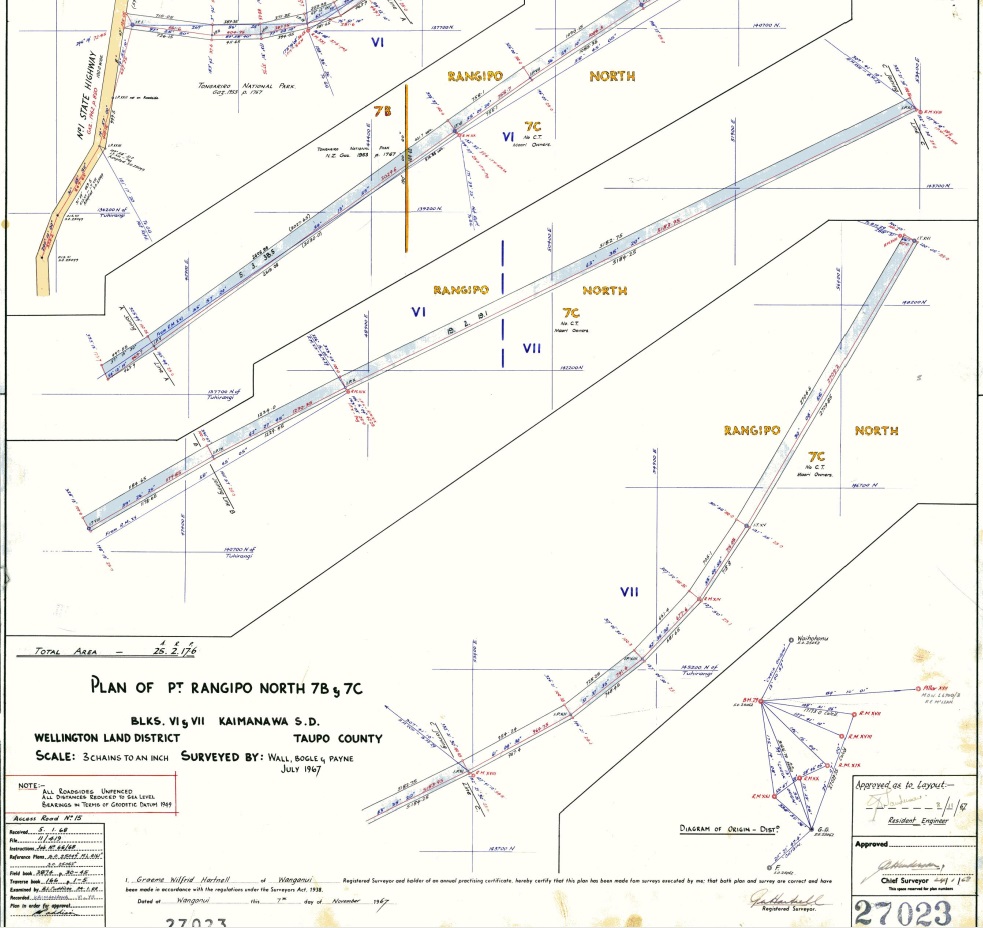
So a quick search of Waipakihi Road shows it is covered by two parcels, Part Rangipo North 7B Block and Part Rangipo North 7C Block. Both these parcels were created by survey SO 27023 1967 shown below....
Attachment 202948
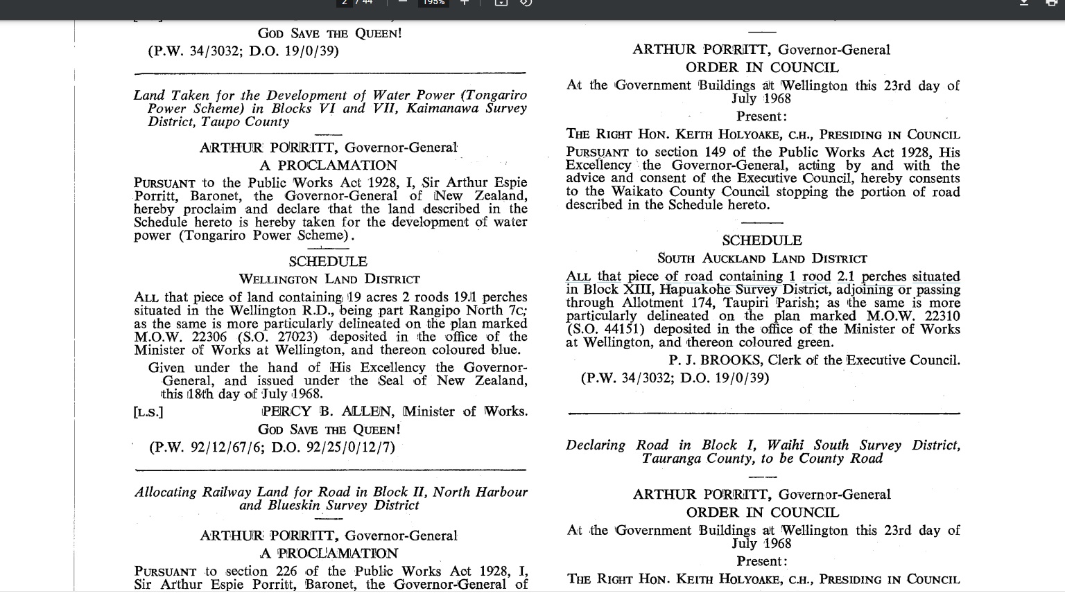
The two parcels have a gazette reference to them - Gazette 1968 p1344 and p1362. The gazette is Government newspaper used for public notification/record to legalise processes and actions under various Acts and Regulations. Road taking or land taking is one of these processes. The two Gazette pages are shown below God Save The Queen!
Attachment 202949
Attachment 202950
As Ruger7mm has mentioned the parcels were taken for "the development of water power (Tongariro Power Scheme)
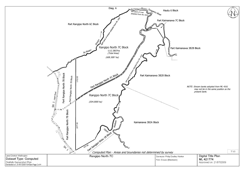
A more recent computed plan of the neighboring Maori land was completed in 2009 - ML 421774. These type of plans were an attempt to work out a more accurate area for blocks of Maori land all over the country. It also shows that the parcels covered by Wapakihi Rd are separate to and not included in the area of the neighboring Maori land. Plan below.....
Attachment 202951
It will be interesting what TDC say about who is in charge of the land as I suspect it will be them. There is some recent survey work being undertaken to the north on Rangipo Intake Rd by a surveyor which might be in a similar situation. Could be a good person to contact to provide more clarity.
Thanks Kickinwings, that helps clarify who doesn't have a legal interest in the road, and also the gazette notice that notes the land was National Park before the acquisition, meaning if the land was no longer needed for the purpose it was taken under the PWA it would be offered back to DOC in the first instance. I am looking forward to the response from TDC now, and whom probably do not wish to be responsible for a road in disrepair.
Bearing in mind that Genisis still reqykre these roads for monitoring and maintainance of their assets so indicating a possible sharing of road maintainance.
TDC initially said it was DOC land when asked via email, and when I checked with the DOC person responsible for boundaries and was told it absolutely wasn't.... TDC decided they would check and get back to us. As yet, nothing.
There is something going on in the background I am beginning to believe, and I would be very unsurprised to find that the "road" has been used as a bargaining chip in settlement negotiations. I would love to be proved wrong, and of course I realise that the Crown can pretty much do as it pleases, but it just isn't adding up.
Something else to think about is that everybody involved in the current talks -FMC, the Iwi, DOC, the settlement negotiators et al are aware of this thread. What I hope the parties who are in elected positions take time to think on is there is an enormous amount of feeling here for the continuation of this particular access point. DOC Turangi and FMC (singing from the same sheet, it appears- and I think there is another story tucked away in there) saying that there are other access points - seriously? I'd like to see someone get to the current road end in less than 8 hours carrying a pack. Essentially it would be a 3 day trip to go for a hunt where the old bridge used to be.
I'm prepared to make this a vote deciding issue for me - in both local and national elections.
Waipakahi road was formed to access a gravel pit required for the building of the power projects so as such may no longer be deemed as required by the power companies.Quote:
Originally Posted by Woody
There is a river gauge at the bottom of the hill on the downstream sideQuote:
Originally Posted by Shearer
Yep.
What about contacting the local press and submitting an article about it?
Starting to make noiseand spreading the noise.
CNI members have arranged a meet with TDC.
Desert Rd closed Thur/Fri 9 AM/6 PM.
One problem is the park boundary is on the far side of the river, so people have already driven across before they see the sign.Quote:
Originally Posted by Woody
So "Woody" asked me to have a quick look at two other roads accessing the Kaimanawas from the Desert Rd and also asked me to post my findings. Tree Trunk Gorge Road and Rangipo Intake Rd.
We use a website called grip.co.nz. It is a GIS website the at you pay a subscription. It is basically a user friendly version of our government cadastral system (called Landonline) and gives you access to survey plans and draft copies of titles etc as well as a NZ wide Aerial photo, it also shows ownership details and so on so is pretty handy (in my line of work anyway). You can sign up for a free trail to check it out.
My findings are below.
Tree trunk Gorge Rd.
Goes through two separate parcels. Part Rangipo North 4B Block and Part Rangipo North 4C Block.
The whole road was surveyed in 1981 on SO 33384-SO 33386 (attached) however it looks like this was never legalised through the gazetting process and so has remained in ownership/part of the original parcels.
Part Rangipo North 4B is the first section covering about the first 900m of the road.
It was gazetted as National Park in 1953
Gazette 1953 p1767
The second half through to the river is on Part Rangipo North 4C Block on Maori land (Title 494393). This is private land.
Rangipo Intake Rd
Goes through Part Rangipo North No 6C Block Maori Land
Road was surveyed In 1971 by SO 28281
The road has been separated from its original parcel however I hit a bit of a wall with trying to find more info on this lot. I suspect it will be in the old Deeds system which are physically held by LINZ and havent been entered online. You are able to get them to send a copy so Ill see if I can track down some more info.
The parcels covering Rangipo Intake Road are split in two and there is a small section in the middle where the physical road isnt covered. There was a survey completed to fix this issue in 1974 but it appears that this was never gazetted and so never actually happened. There is a new recent easement survey (03/05/2022) showing that is being completed at the moment which might be the fix for Genisis for this issue. The gap in the road is shown below. The surveyor undertaking this survey is XXXXXXXX who seems to do a lot of work in this area (he has signed all the recent survey plans around the place).
I have attached another more recent survey plan LT 454308 from 2018 that looks like Genisis have possibly attempted to buy the land covering Rangipo Intake Rd and the right bank of the dam. An LT plan is a survey plan that has been approved by LINZ (in regards to the survey work) but the legal process to complete it and make it legal hasnt been finished or has been abandoned. This seems to be a bit of a theme with the roads in this area so perhaps the land owners have been chopping and changing their minds or are tricky to deal with. The newer easement plan I mentioned earlier is probably Genisis trying to secure access to the dam by easement (right of way) rather than buying the road parcels as separate lots.
So to me it looks as if Waipakihi Rd is the only one that actually got the road land "taken" (or removed from the original parcel) all be it for "Water Development" purposes.
Let me know if you need me to take a squiz at anything else.
Cheers
Thanks for the input on this.
Time to buy an electric bike
An expensive toy to be flogged by the time you walk back to it. Same with vehicles parked near SH1 for a few days while in the bush. Happened to me way back on the Kaimanawa Rd carpark. Police found the culprits in Taupo - local scum who never worked aside from the drug trade.
Do any of these attempted road closures affect vehicle access to the DOC tracks which lead up to Umakarikari or Urchin (i.e/ 'the Tops Loop')?
Thanks
From a 4WD facebook page...
"This has come in from the Outdoor Access Commission regarding Waipakihi and Rangipo access roads
Herenga ā Nuku Aotearoa — The Outdoor Access Commission has received a number of enquiries about the entitlement for public access to the Kaimanawa State Forest Park from the Desert Road and Turangi area. Historically access for recreational pursuits like tramping, hunting, angling and four-wheel driving have used formed roadways like Waipakihi, Rangipo Intake.
These formed roadways originated from the creation of the Tongariro Power Scheme. Waipakihi and Rangipo Intake roads were taken by the Crown in the 1960s under the Public Works Act for the development of the power scheme and held as Crown land. Public access on the roadways (Crown land) has been accepted by the Crown during the time the land has been owned by the Crown. This Crown land is now being returned to the original owners.
The key is that these formed roads were never dedicated as legal roads. Once the land that these formed roads traverse is returned to the original owners, the formed roads will be private roads on private land.
Herenga ā Nuku Aotearoa will now work to assess the options for public access to the Kaimanawa State Forest Park. Due to the level of interest in this access, the Commission’s Chief Executive has contacted FMC national office to engage on this matter"
Copy and paste for me as well.
SERIUOS QUESTION.
It would be useful to us to have an estimate of total visitor numbers to the access roads per year.
Those of you who use these roads will have a few ideas on likely visitor numbrrs. These should include family picnicers, family campers, trampers, sightseers, fishers as well as hunters and assorted hangers-on.
Please give it some careful thought. We need realistic figures and not stupid bs stories please.
Personally I think somewhere over 20,000 annually but you may have better info to base a figure on.
Thanks in advance folks.
I have no input on visitor numbers, but I believe that yes it would be very handy to know.
So now the question is, will the current owner follow the PWA and offer back to the owner off whom the land was taken, which is DOC as the land appears to have been part of the adjoining National Park when it was taken for "Electricity development". I have put this question to Outdoor Access Commission and are awaiting their reply. To offer the land to anyone other than DOC in the first instance would be ignoring the requirements of the PWA, and if DOC have acquiesced and let it go then DOC is not fulfilling their own obligations under the Conservation Act, and some serious questions of them need asking.