

 18Likes
 LinkBack URL
 About LinkBacks
LINZ have high accuracy LIDAR surface over much of the country. For the computer geeks out there there is the ability to create accurate contour maps for sussing out new hunting areas, especially in steep terrain. I have had a crash through using some CAD software and have been able to create maps to print along with routes for upload onto GPS apps. My way was too slow to offer up doing it for others. LINZ have more detail on a way of doing it:
https://www.linz.govt.nz/products-se...elevation-data
https://linz.maps.arcgis.com/apps/Ma...806b085c3fee8a
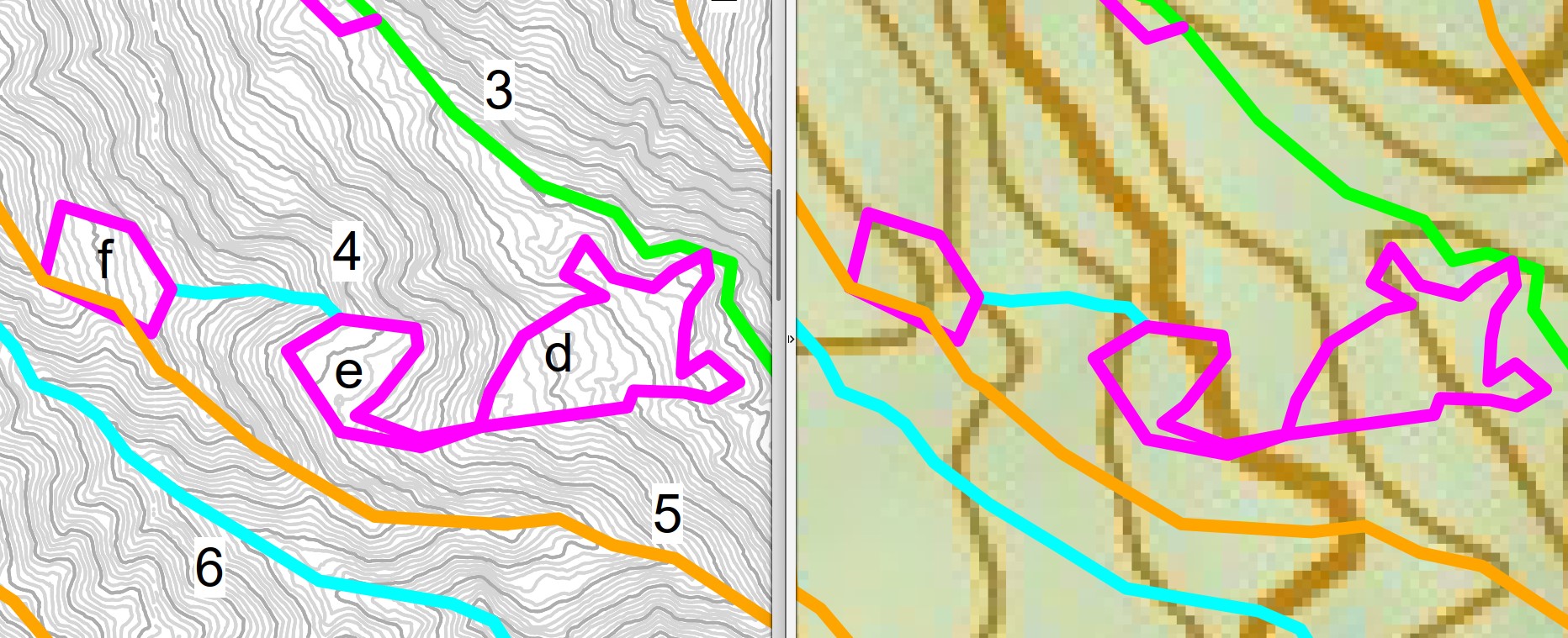
Photo attached showing an example of 1m contours generated from LIDAR vs same area zoomed in on Topo50. I was looking to find flatter areas in the bush and routes that avoided steep terrain on a short time budget. I slapped some letters and numbers on there to help with coms etc.
Is it something anyone has mucked around with?
Welcome guest, is this your first visit? Create Account now to join.
Welcome to the NZ Hunting and Shooting Forums.
Search Forums


User Tag List
+ Reply to Thread
Results 1 to 15 of 20
Thread: High Accuracy Contours?
-
18-03-2025, 03:34 PM #1Member

- Join Date
- Nov 2022
- Location
- Tasman
- Posts
- 12
High Accuracy Contours?
-
-
18-03-2025, 07:26 PM #2Member

- Join Date
- Jan 2023
- Location
- Dunnos
- Posts
- 431
This is cool.
Just need to find a wiz kid to create an app so it’s useful o us old dinosaursMicky Duck likes this.
-
18-03-2025, 07:39 PM #3Member
- Join Date
- Jul 2020
- Location
- Central North Island
- Posts
- 6,085
Show it to a 10 year old. Should have it sorted in half an hour

-
18-03-2025, 07:41 PM #4Member
- Join Date
- Nov 2022
- Location
- Tasman
- Posts
- 12
Yea, all the terrain info is sitting online available to process, but there's so much data its hard to deal with on a large scale. It would be cool if LINZ created an accurate version of Topo50, maybe AI can sort it out.
-
18-03-2025, 09:21 PM #5Member
- Join Date
- Oct 2019
- Location
- Taranaki
- Posts
- 718
Here's a 3d printed model of the kaitake ranges (volunteer on a trapline here) using LINZ data. First attempt adding waterways. Will be looking to refine this for finer detail. Pretty simple workflow to produce these. Not as transportable as a folded map though.

Sent from my SM-A528B using Tapatalk
-
18-03-2025, 09:40 PM #6Member

- Join Date
- Aug 2015
- Location
- wellington
- Posts
- 660
I have been looking at doing this with a CNC router, might have to play with this new data Originally Posted by Ned

-
19-03-2025, 06:27 PM #7Member

- Join Date
- May 2021
- Location
- Christchurch
- Posts
- 355
I've always wondered if NZ Topo 50 is updated following new LINZ LiDAR scans - clearly doesn't seem so. Would've thought it's not too far fetched for LINZ to keep a relatively simple region wide surfaces which merges all the various data from LiDAR scans across Canterbury for example. Unfortunately thought its usually the hills where we hunt that have the lowest resolution. I like the idea though. Makes me think I should export some LiDAR data before the next hunt as well. Even just to have a few images of on the phone or as part of planning
"Knowledge is knowing that a tomato is a fruit ......... wisdom is knowing not to put it in a fruit salad"
-
19-03-2025, 10:19 PM #8Member
- Join Date
- Feb 2022
- Location
- Christchurch
- Posts
- 46
I tend to use the Linz gis website while planning for trips- such a wide variety of data you can import into it which you can layer on top of each other, plus the aerial imagery. I find it can be useful to have that as the base and then add the contour data over top. Free to use so can just go in and have a play round
caberslash likes this.
-
23-06-2025, 03:22 PM #9Member
- Join Date
- Nov 2022
- Location
- Tasman
- Posts
- 12
https://www.topomap.co.nz/ now has a LIDAR layer with much higher definition shading. An offline app would be the next great step.
Eat Meater likes this.
-
23-06-2025, 07:34 PM #10Member

- Join Date
- Apr 2015
- Location
- Geraldine
- Posts
- 28,143
Topo50 is good but satellite photos are crappy and can't zoom in....but of you use google maps once you have sussed out where you want to look,they are much better.
75/15/10 black powder matters
-
24-06-2025, 09:02 AM #11Member
- Join Date
- May 2017
- Location
- Tauranga
- Posts
- 807
Basemaps have even better photos and will give a 3D perspective Originally Posted by Micky Duck
https://basemaps.linz.govt.nzZedrex likes this.
-
27-06-2025, 06:53 PM #12Member

- Join Date
- May 2025
- Location
- CNI
- Posts
- 99
This is super interesting. I have no experience with any of this but having a play with it using AI. Will see how I go and report back.
-
04-07-2025, 12:22 AM #13Member
- Join Date
- Nov 2022
- Location
- Tasman
- Posts
- 12
Apparently Atlogis NZ Maps have added the Lidar layer to their app, but I assume it's only on the subscription version. Ive got the 'pro' version that they stopped supporting a year or two ago and it doesn't come up on that.
Response from Atlogis "We have added your requested hillshade layers to the app. Please update. You find them as baselayer and as overlay. Please click on the (i) symbol (lower left) to adjust transparency of overlay)"
-
04-07-2025, 09:55 AM #14Member

- Join Date
- Apr 2012
- Location
- Napier
- Posts
- 897
Very unlikely to happen due to data sizes, been trying to get hillshade/LiDAR on our work apps and its a smaller area. Been repeatedly told the files are too big for offline use..... Originally Posted by StraightLines
Shame you can only zoom in so far, will still be using other programs to make hunting maps at work.
-
04-07-2025, 11:31 AM #15Member

- Join Date
- Jan 2020
- Location
- Nelson/Tasman
- Posts
- 5,217
Our SAR group has started using CAL Topo which has a shading layer. Don't think the app is available for everyone though unfortunately 😕


 Reply With Quote
Similar Threads
-
Accuracy at 100 vs 600 (example). Variations in accuracy at different ranges
By stagstalker in forum ShootingReplies: 56Last Post: 24-11-2020, 10:35 AM
Tags for this Thread
 Posting Permissions
- You may not post new threads
- You may not post replies
- You may not post attachments
- You may not edit your posts
Welcome to NZ Hunting and Shooting Forums! We see you're new here, or arn't logged in. Create an account, and Login for full access including our FREE BUY and SELL section Register NOW!!
All times are GMT +13. The time now is 04:28 PM.

Bookmarks