

 20Likes
 LinkBack URL
 About LinkBacks
Paper backup is good coz I hate wiping my ass with my phone!Originally Posted by MattyP


Welcome guest, is this your first visit? Create Account now to join.
Welcome to the NZ Hunting and Shooting Forums.
Search Forums


User Tag List
+ Reply to Thread
Results 31 to 45 of 78
Thread: Garmin Monterra GPS
-
16-12-2013, 12:29 PM #31Muppets Inc.


- Join Date
- Jun 2012
- Location
- Napier
- Posts
- 303
Gibo likes this.
-
-
16-12-2013, 12:54 PM #32Member
- Join Date
- Aug 2013
- Location
- Christchurch
- Posts
- 449
Definitely! I just laminated all my permits and printed maps from New Zealand Topographic Map - NZ Topo Map . Pretty handy, adds bugger all more weight and stops them getting wet/crunched up beyond reading. The downside is you can't wipe anything with them
.
What I would like more than anything with a GPS/Phone is 1:50,000 maps with DOC approved hunting areas on them. Something to be able to glance at quickly and see, yup i'm in the hunting area. Or, nope, few hundred meters more yet. Ass covering is always good.
I've manually gone through on Viewranger and added the approved hunting areas to a couple of places i'll be visiting. I used the path or trail setting function (can't remember name) to draw them in. Only takes a few minutes using one of the DOC maps for reference, but it won't be perfect so i've erred on the side of caution.
-
16-12-2013, 12:57 PM #33Member
- Join Date
- Aug 2012
- Location
- Christchurch
- Posts
- 4,634
Wow ok those apps are awesome especially tge locus one. Will test out on my next hunt and see what reception is like compared to the rhino... could be a rhino up for sale soon ha ha
Munsey likes this.
-
16-12-2013, 01:08 PM #34Member
- Join Date
- Aug 2013
- Location
- Christchurch
- Posts
- 449
Does the Locus one have 1:50,000 maps? The screenshot looks like 1:250,000 at best, which are free on every app i've seen.
I like the sat overlay though!
-
16-12-2013, 01:11 PM #35Member
- Join Date
- Aug 2012
- Location
- Christchurch
- Posts
- 4,634
Just had better look and I think they are 250,000 as you can't zoom very far. Overlay is cool.
Anyone no how to get satellite images on a standard gps like rhino?
-
16-12-2013, 01:26 PM #36Member

- Join Date
- Feb 2012
- Location
- Westland NZ
- Posts
- 16,102
That satellite overlay would be the shit!!! I only seem to use a GPS for wallow and track marking or if ever in flat bush somewhere new. But I do appreciate all the extras you can get.
Do what ya want! Ya will anyway.
-
16-12-2013, 01:30 PM #37GSP Mad

- Join Date
- Mar 2012
- Location
- Christchurch
- Posts
- 5,237
I in same boat didn't really need a rino after all . I always assumed you need cell coverage to make it all work . Downloaded that app last night on iPad and iPhone it's pretty cool . Already got otter case for cell and waterproof case for pad . Please no one tell me there is a app that turns cell phone Into UHF Originally Posted by PerazziSC3
 R93 likes this.Rule 7: Avoid alcohol and drugs when handling firearms
-
16-12-2013, 01:33 PM #38Member
- Join Date
- Aug 2012
- Location
- Christchurch
- Posts
- 4,634
Ha ha to right munsey it's quite bad really how far behind a handheld gps is when compared to smart phones, sure they are a bit more rugged but screen resolution and sensitivity is pretty much like a 5 year old phone... I do like the buddy location and message feature on the rhino tho..
Munsey likes this.
-
16-12-2013, 01:50 PM #39Codswallop


- Join Date
- Feb 2013
- Location
- The Hill
- Posts
- 23,600
Screen resolution and processing speed on my 650 is pretty sweet. Has a 8 megapixel camera, led flash that doubles as a light. I dont know what it is but I just cant rely on my iPhone for this stuff. To fragile? Originally Posted by PerazziSC3
I think the smartphone companies should start building purpose built GPS units and drive the tech up and cost down.
-
16-12-2013, 01:56 PM #40Member
- Join Date
- Aug 2012
- Location
- Christchurch
- Posts
- 4,634
What model Gibo? I guess if I was to compare a 62s specs to a smart phone (62s normally $500 ish) I could get everything the 62 has plus a half decent camera and 10x better screen not to mention apps ect in a $80 smart phone....
The selling point for me on the rhino is the radio/message feature...
Now what I would buy would be one of these monterras, with a radio feature and a plb all in one unit. That would be an awesome bit of kit
-
16-12-2013, 02:16 PM #41GSP Mad
- Join Date
- Mar 2012
- Location
- Christchurch
- Posts
- 5,237
What's the "buddy feature " on view ranger ?
Rule 7: Avoid alcohol and drugs when handling firearms
-
16-12-2013, 02:26 PM #42Codswallop
- Join Date
- Feb 2013
- Location
- The Hill
- Posts
- 23,600
This one. Originally Posted by PerazziSC3
https://buy.garmin.com/en-US/US/on-t...rod113520.html
-
16-12-2013, 03:12 PM #43Member
- Join Date
- Aug 2013
- Location
- Christchurch
- Posts
- 449
You can check where friends have been and stuff like that if you both allow it. Don't believe it's live though - or not unless you have cell reception. Could come in handy though if you wanted to tell a mate about a real good spot, etc. Originally Posted by Munsey
I nearly bought a top of the range dedicated GPS but then just thought i'd check what sort of apps are available. There are far too many reports of the GPS on top of the line phones outperforming the dedicated GPS devices. To me the only advantage is the durability or ruggedness, as mentioned. But I think that can be negated.
I'm glad i've limited my devices, but still have to carry phone, binos, rangefinder, plb. Now if someone could come up with a smart phone that was also a PLB and maybe even a rangefinder.....
-
17-12-2013, 10:31 AM #44Muppets Inc.
- Join Date
- Jun 2012
- Location
- Napier
- Posts
- 303
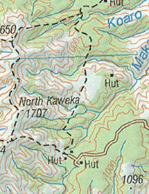
Yup is 1:50000 for sure, remember you don't get the 20 meter contours on 1:250000 scale maps (same as the old paper maps). Contours are 100m @ 1:250000 I believe. The area in the screen shot is basically 1 square km, with contour lines every 20m. Don't mistake a unclear zoom level for map scale. Overall clarity of the Topo50 maps depends on the zoom level incorporated into the maps, the higher the zoom level the greater the file size as you need more tiles for a given area. Basically in Locus once the max available zoom level is reached in a given map you can choose via settings to either lock the zoom or continue zooming where the image is simply enlarged, thus going unclear. Originally Posted by MattyP
Try the zoom slider on www.nztopomaps (it has the different map scales bracketed on the zoom slider)
1:250000 scale on same area (from PC)Last edited by SIKAHUNTER; 17-12-2013 at 10:37 AM.
-
17-12-2013, 11:04 AM #45Muppets Inc.
- Join Date
- Jun 2012
- Location
- Napier
- Posts
- 303
You'd need to add them as a layer similar to the Garmin Custom Maps overlay Topo50 maps that you can download off topomap.co.nz. Standby and I'll whip a test Sat overlay for Garmins and post link to it. Originally Posted by PerazziSC3


 Reply With Quote
Similar Threads
-
garmin 62s
By nork1122 in forum Gear and EquipmentReplies: 9Last Post: 15-07-2013, 04:08 PM -
garmin 62s, which sd card?
By foxhound in forum Gear and EquipmentReplies: 0Last Post: 09-03-2013, 06:19 PM
Tags for this Thread
- 260,
- 300,
- 5000,
- accurate,
- adventure,
- app,
- atlas,
- ballistics,
- bucks,
- buy,
- camera,
- canopy,
- case,
- cheap,
- coast,
- day trip,
- deer,
- device,
- farmer,
- garmin,
- gear,
- gps,
- handheld,
- information,
- iphone,
- kawekas,
- legend,
- loads,
- lost,
- maps,
- offline,
- pack,
- packs,
- pants,
- permits,
- phone,
- plb,
- r93,
- radio,
- rangefinder,
- ranger,
- ranges,
- receiver,
- rino,
- rust,
- satellite,
- sony,
- south island,
- tahr hunting,
- tents,
- test,
- top,
- topo maps,
- trip,
- turn,
- usa,
- water proof,
- waterproof,
- west coast
 Posting Permissions
- You may not post new threads
- You may not post replies
- You may not post attachments
- You may not edit your posts
Welcome to NZ Hunting and Shooting Forums! We see you're new here, or arn't logged in. Create an account, and Login for full access including our FREE BUY and SELL section Register NOW!!
All times are GMT +13. The time now is 10:38 PM.

Bookmarks