

 993Likes
 LinkBack URL
 About LinkBacks
I wonder if helisika or their associates have a concession to run mountainbiking business in the kaimanawa forest park ?
Current established cash flows from aerial access there are:
Recreational hunters
Predator control
Sika foundation herd management
Welcome guest, is this your first visit? Create Account now to join.
Welcome to the NZ Hunting and Shooting Forums.
Search Forums


User Tag List
+ Reply to Thread
Results 61 to 75 of 592
Thread: Kaimanawa Forest Park
-
19-07-2022, 01:37 PM #61Member

- Join Date
- Mar 2012
- Location
- Waikato
- Posts
- 1,956
-
-
19-07-2022, 01:42 PM #62Member
- Join Date
- Jul 2020
- Location
- Central North Island
- Posts
- 4,324
Its only going to affect the law abiding (sound familiar!!!)
The locals all know a dozen ways to get in there that's not along the sealed road.
-
19-07-2022, 03:21 PM #63Member
- Join Date
- Feb 2014
- Location
- Taupo
- Posts
- 483
Drove past the intake rd and large steel posts 40m from state h/way, nothing visible on kaimanawa rd
-
19-07-2022, 09:00 PM #64Member
- Join Date
- Jun 2015
- Location
- Bay of plenty
- Posts
- 709
They will still need a resource consent for a place of assembly I guess unless Māori land is exempt from the RMA Originally Posted by Mohawk .308

-
19-07-2022, 10:02 PM #65Member
- Join Date
- Mar 2012
- Location
- Waikato
- Posts
- 1,956

Access to the Urchin and Umukarikari tracks is also not on public roads.
-
19-07-2022, 10:12 PM #66Member
- Join Date
- Feb 2012
- Location
- Stratford
- Posts
- 73
I'm lead to believe that the Kaimanawa road has an untouchable public right of way attached to it...
-
19-07-2022, 11:27 PM #67Member
- Join Date
- Feb 2017
- Location
- Jafa land
- Posts
- 5,331
you might be associating decades of public use with public road. Let's wait for WAMS to ge tinvolved and see what they say. Originally Posted by Hindquarters
-
20-07-2022, 09:27 AM #68Member

- Join Date
- Dec 2014
- Location
- NZISTAN
- Posts
- 5,216
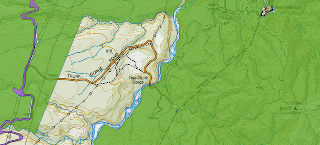
The Council GIS shows Road Reserve on all except tree trunk. Originally Posted by Bagheera
-
20-07-2022, 09:29 AM #69Member
- Join Date
- Dec 2014
- Location
- NZISTAN
- Posts
- 5,216
What GIS is that? Originally Posted by Bagheera
-
20-07-2022, 10:59 AM #70Caretaker

- Join Date
- May 2012
- Location
- Rolleston, Canterbury
- Posts
- 4,871
There is/use to be another road/track between Kaimanawa Rd and Tree trunk gorge. We used it once when Kaiwanawa Rd first went to the permit system. There was a footbridge over the river and came out on the Pillars of Hercules track. No place to leave the car though.
Woody likes this.
-
20-07-2022, 11:21 AM #71Member

- Join Date
- Nov 2015
- Location
- Wanganui no H
- Posts
- 489
If you are referring to the maps Bagheera put up, I dont think they are GIS maps but Topo with DoC overlay on. Could be wrong Originally Posted by 300CALMAN
-
20-07-2022, 12:07 PM #72Member
- Join Date
- Feb 2013
- Location
- Mangakino
- Posts
- 1,724
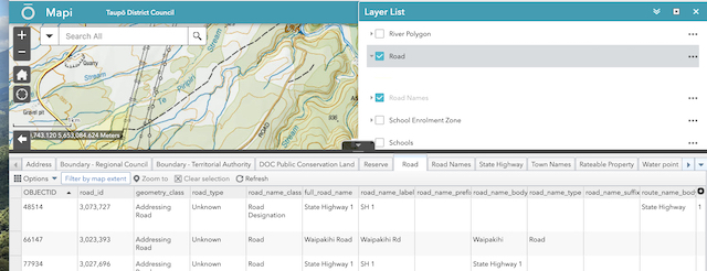
Have a bit of a play on Taupo District Council mapping system.
Not sure how to use properly but somebody on here will know.
https://taupo.maps.arcgis.com/apps/w...0c3144560264f6
-
20-07-2022, 02:35 PM #73Member
- Join Date
- Mar 2012
- Location
- Waikato
- Posts
- 1,956
Thanks @erniec .
The Taupo Council map seems like the same tool as on the Walking Access Govt site but with different data.
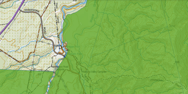
I can see a yellow line along some of those roads but it's just described as "road" and its' legal / public access status isn't shown. This is what I could find for Waipakihi Rd:
I think on this forum we're limited in what we can reliably find out about the legal status, whether it's public road, easement, covenant or customary use. However, this is a great platform for spreading true, surmised or rumoured news. It would be reliable if someone were to post photos or recount any experience of restricted access, preferably with a police file number if a complaint were to be made. Representatives of Helisika and the land owners should also be respectfully invited to tell us what's up for them. Often, there is a period before changes are finalised, when things can be negotiated, which is more efficient for all involved.Danny likes this.
-
20-07-2022, 03:07 PM #74Member
- Join Date
- Jul 2020
- Location
- Central North Island
- Posts
- 4,324
Unfortunately I think the time for that has passed. The initial leverage for maintaining permanent access would have been during the Tongariro power project construction phase, when public assets were constructed/placed at the end of those roads (water intakes/diversions, hydro power stations). There may well be ROW over the roads to enable the Ministry of Electricity and its successors to freely access/work/maintain that infrastructure. But possibly not over the Waipakahi road, as there's only a river level gauge down at the end of the road .
The only other possible period to have negotiated a right of way over the Waipakahi road would have been during the negotiations for the Provincial Growth Fund that paid for a lot of the works carried out. Trouble being I doubt that the public servants dishing out the PGF lollies would have had the foresight or acumen to have made Public Access a condition when doling out public funds in the form of the grant (i.e. for free) for a private Trust and a successful business to make money from.
-
20-07-2022, 03:23 PM #75Member

- Join Date
- Feb 2015
- Location
- Rangitikei
- Posts
- 501
https://www.lrft.co.nz/land.html Third Schedule blocks,clickable link.
Shearer likes this.


 Reply With Quote
Similar Threads
-
Pirongia Forest Park
By Shadowsol in forum HuntingReplies: 4Last Post: 16-03-2020, 05:53 PM -
Tongariro Nat Park (Hauhungatahi) or Kaimanawa Forest Park
By BLABLANZ in forum HuntingReplies: 5Last Post: 31-01-2017, 08:56 PM -
FOUND - DOG - (KAIMANAWA FOREST PARK)
By Barat in forum Hunting DogsReplies: 1Last Post: 06-11-2016, 08:38 AM -
Kaimai forest park
By kawekakid in forum HuntingReplies: 19Last Post: 22-04-2014, 07:19 PM -
Aorangi Forest Park
By D1Hilux in forum HuntingReplies: 2Last Post: 05-11-2013, 07:32 AM
Tags for this Thread
 Posting Permissions
- You may not post new threads
- You may not post replies
- You may not post attachments
- You may not edit your posts
Welcome to NZ Hunting and Shooting Forums! We see you're new here, or arn't logged in. Create an account, and Login for full access including our FREE BUY and SELL section Register NOW!!
All times are GMT +13. The time now is 03:13 AM.

Bookmarks